3D coverage
Mechanical azimuth scan plus elevation digital beamforming; 360° azimuth, −5° to 60° elevation.

Radar · DD-R10
DD-R10 is a three-dimensional low-altitude surveillance radar that detects and continuously tracks drones, aircraft and birds, while also monitoring ground targets such as people and vehicles, and surface targets such as vessels. It uses a low-power continuous-wave design that is harder to intercept than pulse radar, and can guide EO/IR cameras and other sensors inside a cooperative detection system.
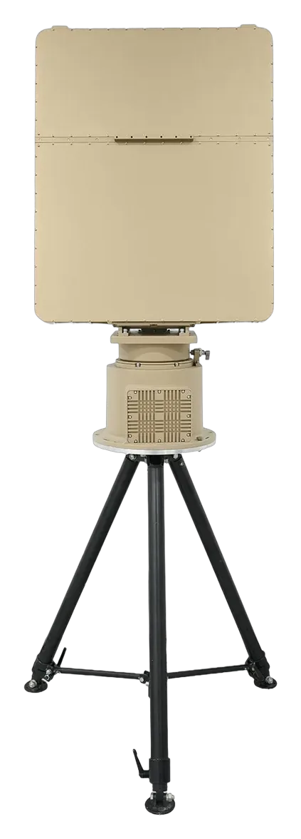
X-band 3D radar for drones, aircraft, birds, vehicles and vessels, with ≥ 500 simultaneous tracks.
Mechanical azimuth scan plus elevation digital beamforming; 360° azimuth, −5° to 60° elevation.
Range ≤ 5 m, velocity ≤ 0.5 m/s, angle ≤ 0.3° (RMS).
Continuous-wave operation at low transmit power, harder to detect than pulse radar.
Extracts weak targets against ground or weather clutter with a low false-alarm rate.
Modular design; host and pedestal pack into two aluminium transport cases.
Four low-altitude radars share one architecture and differ in band, range and size. The model number follows the detection range for a small drone.
| Model | Band | Small UAV (RCS 0.01 m²) | Medium UAV (RCS 1 m²) | Max altitude | Elevation | Tracks | Power | Weight (host + pedestal) |
|---|---|---|---|---|---|---|---|---|
| DD-R1 | Ku-band | ≥ 1.5 km | ≥ 3.5 km | 600 m | −5° to 60° | ≥ 100 | ≤ 120 W | ≤ 23 kg |
| DD-R5 | X-band | ≥ 5 km | ≥ 10 km | 1000 m | −5° to 40° | ≥ 200 | ≤ 260 W | ≤ 29 kg |
| DD-R8 | X-band | ≥ 8 km | ≥ 15 km | 2000 m | −4° to 60° | ≥ 300 | ≤ 330 W | ≤ 33 kg |
| DD-R10 | X-band | ≥ 10 km | ≥ 20 km | 3000 m | −5° to 60° | ≥ 500 | ≤ 400 W | ≤ 52 kg |
Source: DD-R1, DD-R5, DD-R8 and DD-R10 specification sheets (December 2025). All four: 360° azimuth, 50 m blind zone, range accuracy ≤ 5 m, IP66 (host IP67). Ask us which model fits your site.
Figures are taken from the DD-R10 specification sheet (December 2025). Performance depends on site, target and environment.
| Operating band | X-band |
|---|---|
| Technology | Mechanical azimuth scan + elevation DBF |
| Detection range | 20 km |
| Small UAV (RCS 0.01 m², DJI Phantom 4) | ≥ 10 km |
| Medium UAV (RCS 1 m²) | ≥ 20 km |
| Car / helicopter (RCS 5 m²) | ≥ 20 km |
| Maximum detection altitude | 3000 m |
| Blind zone | 50 m |
| Azimuth / elevation coverage | 360° / −5° to 60° |
| Velocity measurement range | 1–150 m/s |
| Accuracy (RMS) | Range ≤ 5 m; velocity ≤ 0.5 m/s; azimuth and elevation ≤ 0.3° |
| Refresh rate | 2 s (30 rpm, standard); 3 s (20 rpm); 1 s (60 rpm, upgradeable) |
| Simultaneous tracking capacity | ≥ 500 targets |
| Operating temperature / humidity | −40 to +55 °C; ≤ 90 % |
| Protection rating | IP66 (radar host IP67) |
| Power | DC 36–52 V (AC 220 V to DC 48 V adapter supplied); ≤ 400 W |
| Interface | Ethernet (circular aviation connector) |
| Size / weight | ≤ 52 kg host + pedestal (host ≤ 655 × 815 × 116 mm, ≤ 25 kg; pedestal ≤ 520 × Ø380 mm, ≤ 27 kg). Tripod ≤ 1100 × 450 × 450 mm, ≤ 20 kg |
Standard and optional items listed in the specification sheet. Final packing list is confirmed in your quotation.
Combine sensors and response equipment into one system around your site plan.
FAQ
The DD-R10 is an X-band, three-dimensional low-altitude surveillance radar. It detects and tracks drones, aircraft and birds, and also monitors people, vehicles and surface vessels.
A small drone with a radar cross-section of 0.01 m² (for example a DJI Phantom 4) is detected at 10 km or more; a 1 m² target at 20 km or more. Maximum detection altitude is 3000 m and the blind zone is 50 m.
500 or more simultaneous tracks, with a standard refresh time of 2 seconds (1 second as an upgrade).
Yes. It can cue EO/IR cameras and other sensors inside a cooperative detection system.
On a fixed mount, a tripod or a vehicle. The host and pedestal pack into two aluminium transport cases. The radar is rated IP66 (host IP67) and runs on DC 36–52 V at 400 W or less.
Tell us about the site, environment and quantity. We reply by email with the next step.